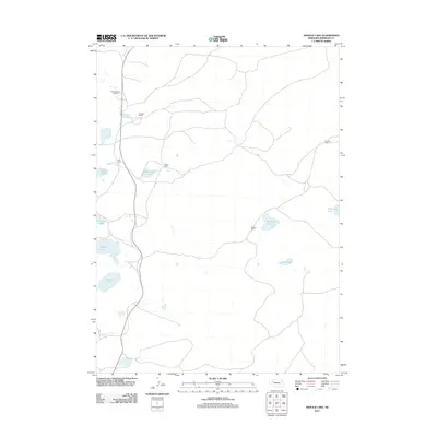
2011 Map of Arnold Lake
USGS Topo · Published 2011About this map
The Sheridan County Sandhills are defined by an intricate network of small water bodies and isolated homesteads. Water is the primary geographic anchor here, with Arnold Lake and Walters Lake marking the lower elevations of the terrain. The landscape is dotted with several other basins, including Roethler Lake, Wintermuth Lake, and Carnes Lake, which suggest the characteristic topography of western Nebraska. Settlement patterns are sparse and agrarian, anchored by family-named ranching operations. Significant holdings such as the Messersmith Ranch, Sowards Ranch, and Leisy Ranch are connected by a web of local roads, reflecting the large-scale land management required in this environment. To the east, the map identifies additional landmarks like Watson Lake and the Brennan Ranch, illustrating the remote but persistent human presence in this region of the High Plains.
Find a feature on this map
14 named features on this map. Tap any name to fly to it.
Don’t see what you’re looking for? This feature index may not catch every label — zoom into the map to look around manually.
Map Details
Editions of this 2011 Arnold Lake Map
This is the sole edition of this map. No revisions or reprints were ever made.
Other maps of this area

1948 · Bingham
USGS Topo · 1:62,500

1948 · Lakeside
USGS Topo · 1:62,500

1948 · Twin Lakes
USGS Topo · 1:62,500

1948 · Spade Ranch
USGS Topo · 1:62,500

1950 · Twin Lakes
USGS Topo · 1:62,500

1950 · Spade Ranch
USGS Topo · 1:62,500

1950 · Lakeside
USGS Topo · 1:62,500

1950 · Bingham
USGS Topo · 1:62,500

1955 · Alliance
USGS Topo · 1:250,000

1957 · Alliance
USGS Topo · 1:250,000