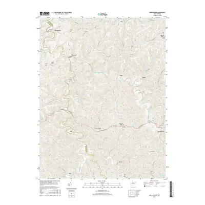
2016 Map of Arnoldsburg
USGS Topo · Published 2016About this map
The West Fork Little Kanawha River meanders through this portion of Calhoun and Roane Counties, anchoring a network of small valley settlements and highland ridges. The community of Arnoldsburg serves as a local hub near the confluence of Mushroom Run and the river, while smaller hamlets like Pink, Leatherbark, and Rocksdale are linked by winding routes such as Arnoldsburg Rd. The landscape is characterized by its numerous family and community burial grounds, including Arnoldsburg Cem, Liberty Hill Cem, and Starcher Cem, providing a dense record of local lineage. The infrastructure of the era is evident at the Rocksdale Bridge and the various county roads that follow the contours of the terrain. High points like Egypt Ridge and Husher Ridge separate the many drainage forks, such as Icy Fork and Dennis Fork, which define the agricultural and residential patterns of this Appalachian landscape.
Find a feature on this map
112 named features on this map. Tap any name to fly to it.
Don’t see what you’re looking for? This feature index may not catch every label — zoom into the map to look around manually.
Map Details
Editions of this 2016 Arnoldsburg Map
This is the sole edition of this map. No revisions or reprints were ever made.
Other maps of this area

1906 · Otter
USGS Topo · 1:62,500

1906 · Walton
USGS Topo · 1:62,500

1907 · Otter
USGS Topo · 1:62,500

1907 · Arnoldsburg
USGS Topo · 1:62,500

1907 · Spencer
USGS Topo · 1:62,500

1907 · Walton
USGS Topo · 1:62,500

1925 · Arnoldsburg
USGS Topo · 1:62,500

1927 · Arnoldsburg
USGS Topo · 1:62,500

1928 · Spencer
USGS Topo · 1:62,500

1954 · Charleston
USGS Topo · 1:250,000