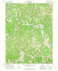
1965 Map of Arnoldsburg
USGS Topo · Published 1967About this map
The Little Kanawha River carves a winding path through the central West Virginia hills on this 1965 survey, defining the rural character of southeastern Calhoun County. The landscape is dominated by narrow valleys and ridgelines, where dozens of oil and gas wells signify the area's energy-driven economy. Small community hubs like Arnoldsburg and Richardson are documented alongside specialized local landmarks, including a Gaging Station and the Daniels Run Sch.
Find a feature on this map
75 named features on this map. Tap any name to fly to it.
Don’t see what you’re looking for? This feature index may not catch every label — zoom into the map to look around manually.
Map Details
Editions of this 1965 Arnoldsburg Map
This is the sole edition of this map. No revisions or reprints were ever made.
Other maps of this area

1906 · Otter
USGS Topo · 1:62,500

1906 · Walton
USGS Topo · 1:62,500

1907 · Otter
USGS Topo · 1:62,500

1907 · Arnoldsburg
USGS Topo · 1:62,500

1907 · Spencer
USGS Topo · 1:62,500

1907 · Walton
USGS Topo · 1:62,500

1925 · Arnoldsburg
USGS Topo · 1:62,500

1927 · Arnoldsburg
USGS Topo · 1:62,500

1928 · Spencer
USGS Topo · 1:62,500

1954 · Charleston
USGS Topo · 1:250,000