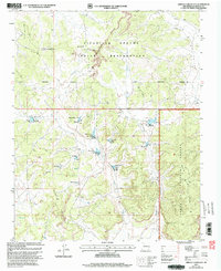
2002 Map of Arroyo Chijuillita
USGS Topo · Published 2003About this map
The Continental Divide winds through this high-elevation landscape, marking a significant hydrological and cultural boundary between the Jicarilla Apache Indian Reservation and the Santa Fe National Forest. This 2002 revision shows an intricate system of water management infrastructure, including Retention Dam No 4, Retention Dam No 8, and Retention Dam No 133, designed to control seasonal runoff within the arid drainage of Arroyo Chijuillita.
Find a feature on this map
24 named features on this map. Tap any name to fly to it.
Don’t see what you’re looking for? This feature index may not catch every label — zoom into the map to look around manually.
Map Details
Editions of this 2002 Arroyo Chijuillita Map
This is the sole edition of this map. No revisions or reprints were ever made.
Other maps of this area

1883 · Mt. Taylor
USGS Topo · 1:250,000

1886 · Mt. Taylor
USGS Topo · 1:250,000

1889 · Largo
USGS Topo · 1:250,000

1890 · Jemes
USGS Topo · 1:125,000

1892 · Jemes
USGS Topo · 1:125,000

1892 · Mt. Taylor
USGS Topo · 1:250,000

1895 · Largo
USGS Topo · 1:250,000

1899 · Mt. Taylor
USGS Topo · 1:250,000

1909 · Gallina
USGS Topo · 1:125,000

1939 · La Ventana
USGS Topo · 1:62,500