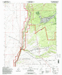
1995 Map of Arroyo Hondo
USGS Topo · Published 1998About this map
The Rio Grande carves a deep path through northern New Mexico in this mid-1990s survey, marking a stark division between the open plains to the west and the high country of the Carson National Forest to the east. The valley floor is defined by historic land divisions including the Antoine Leroux Grant and the Taos Pueblo Grant, reflecting a long history of communal land use and settlement. Along the Rio Hondo, the village of Arroyo Hondo serves as a primary hub of activity, with the Lady of Sorrows Ch and the Raei Cem providing clear markers for genealogists and local historians. To the north, the smaller settlement of San Cristobal sits near the base of Garrapata Ridge Canyon. Significant natural landmarks like Cebolla Mesa and Manby Hot Springs underscore the varied terrain of this high-desert landscape.
Find a feature on this map
30 named features on this map. Tap any name to fly to it.
Don’t see what you’re looking for? This feature index may not catch every label — zoom into the map to look around manually.
Map Details
Editions of this 1995 Arroyo Hondo Map
This is the sole edition of this map. No revisions or reprints were ever made.
Other maps of this area

1954 · Raton
USGS Topo · 1:250,000

1958 · Raton
USGS Topo · 1:250,000

1961 · Tres Orejas
USGS Topo · 1:24,000

1963 · Arroyo Seco
USGS Topo · 1:24,000

1963 · Arroyo Hondo
USGS Topo · 1:24,000

1963 · Tres Piedras NE
USGS Topo · 1:24,000

1963 · Cerro De Los Taoses
USGS Topo · 1:24,000

1963 · Questa
USGS Topo · 1:24,000

1963 · Guadalupe Mountain
USGS Topo · 1:24,000

1964 · Los Cordovas
USGS Topo · 1:24,000