
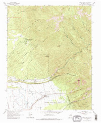
1963 Map of Arroyo Seco
USGS Topo · Published 1967About this map
Arroyo Seco and the village of Valdez anchor the southern reaches of this landscape, where the agricultural life of the valley meets the rising peaks of the Carson National Forest. The map documents a complex system of historical land grants, including the Antoine Leroux and Antonio Martinez or Godoi grants, which define the property boundaries across the high desert and mountains. Higher elevations are characterized by landmarks like Lobo Peak and Gallina Peak, accessible by a network of paths such as the Manzanita Trail and Verba Canyon Trail.
Find a feature on this map
45 named features on this map. Tap any name to fly to it.
Don’t see what you’re looking for? This feature index may not catch every label — zoom into the map to look around manually.
Map Details
Editions of this 1963 Arroyo Seco Map
2 editions found
Other maps of this area

1954 · Raton
USGS Topo · 1:250,000

1958 · Raton
USGS Topo · 1:250,000

1963 · Wheeler Peak
USGS Topo · 1:24,000

1963 · Arroyo Hondo
USGS Topo · 1:24,000

1963 · Questa
USGS Topo · 1:24,000

1963 · Guadalupe Mountain
USGS Topo · 1:24,000

1963 · Red River
USGS Topo · 1:24,000

1964 · Los Cordovas
USGS Topo · 1:24,000

1964 · Taos
USGS Topo · 1:24,000

1965 · Pueblo Peak
USGS Topo · 1:24,000