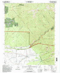
1995 Map of Arroyo Seco
USGS Topo · Published 1997About this map
The Antoine Leroux Grant and several other Spanish and Mexican land grants define the social and physical geography of this 1995 revision. The landscape is split between the high peaks of the Sangre De Cristo Mountains and the irrigated valley settlements along the Rio Hondo. Small communities like Valdez and Arroyo Seco sit at the mouths of deep canyons, illustrating a traditional settlement pattern tied to water rights and mountain access.
Find a feature on this map
39 named features on this map. Tap any name to fly to it.
Don’t see what you’re looking for? This feature index may not catch every label — zoom into the map to look around manually.
Map Details
Editions of this 1995 Arroyo Seco Map
This is the sole edition of this map. No revisions or reprints were ever made.
Other maps of this area

1954 · Raton
USGS Topo · 1:250,000

1958 · Raton
USGS Topo · 1:250,000

1963 · Wheeler Peak
USGS Topo · 1:24,000

1963 · Arroyo Seco
USGS Topo · 1:24,000

1963 · Arroyo Hondo
USGS Topo · 1:24,000

1963 · Questa
USGS Topo · 1:24,000

1963 · Guadalupe Mountain
USGS Topo · 1:24,000

1963 · Red River
USGS Topo · 1:24,000

1964 · Los Cordovas
USGS Topo · 1:24,000

1964 · Taos
USGS Topo · 1:24,000