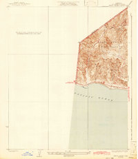
1932 Map of Arroyo Sequit
USGS Topo · Published 1942About this map
The coastal terrain where the Santa Monica Mountains meet the Pacific Ocean is the primary focus of this topography from the early 1930s. The survey reveals a sparsely developed landscape defined by deep canyons and the winding path of Arroyo Sequit. Coastal access is dominated by the Roosevelt Highway, later designated as U. S. Route No. 101, which hugs the shoreline near Sequit Pt. This era shows Malibu before the intensive modern development of the late 20th century, where the steep topography and drainage basins like Nicholas Canyon dictated the limited placement of early roads and structures. The map serves as a detailed record of the Ventura and Los Angeles County line before the massive expansion of the Southern California highway system.
Find a feature on this map
10 named features on this map. Tap any name to fly to it.
Don’t see what you’re looking for? This feature index may not catch every label — zoom into the map to look around manually.
Map Details
Editions of this 1932 Arroyo Sequit Map
3 editions found
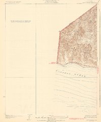
Other maps of this area

1900 · Triunfo Pass
USGS Topo · 1:62,500

1903 · Camulos
USGS Topo · 1:125,000

1904 · Hueneme
USGS Topo · 1:62,500

1921 · Triunfo Pass
USGS Topo · 1:62,500

1929 · Dume Point
USGS Topo · 1:24,000

1932 · Dume Point
USGS Topo · 1:24,000

1932 · Russell Valley
USGS Topo · 1:24,000

1932 · Arroyo Sequit
USGS Topo · 1:24,000

1942 · Hueneme
USGS Topo · 1:62,500

1943 · Hueneme
USGS Topo · 1:62,500
Featured Places
- Malibu, CA
- South Beach, CA
- Unincorporated Santa Monica Mountains, CA
- Ventura County, CA
- Los Angeles County, CA