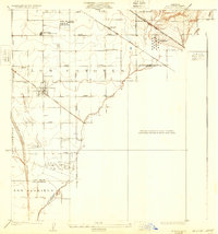
1925 Map of Artesia
USGS Topo · Published 1932About this map
Artesia and the surrounding Los Angeles County landscape are defined by an evolving early 20th-century intersection of agriculture, petroleum infrastructure, and sprawling rail lines. The Pacific Electric and Southern Pacific railroads crisscross the territory, serving as the primary arteries for a region transitioning toward industrialization. The presence of the C.C. Julian Tank Farm and the Standard Oil Pumping Sta near the border of La Mirada highlights the vital role of the oil industry in this era.
Find a feature on this map
31 named features on this map. Tap any name to fly to it.
Don’t see what you’re looking for? This feature index may not catch every label — zoom into the map to look around manually.
Map Details
Editions of this 1925 Artesia Map
2 editions found
Other maps of this area

1896 · Anaheim
USGS Topo · 1:62,500

1896 · Downey
USGS Topo · 1:62,500

1898 · Anaheim
USGS Topo · 1:62,500

1899 · Downey
USGS Topo · 1:62,500

1901 · Southern California Sheet No. 1
USGS Topo · 1:250,000

1901 · Anaheim
USGS Topo · 1:62,500

1902 · Downey
USGS Topo · 1:62,500

1902 · Corona
USGS Topo · 1:125,000

1904 · Southern California Sheet No. 1
USGS Topo · 1:250,000
1923 · Bell
USGS Topo · 1:24,000