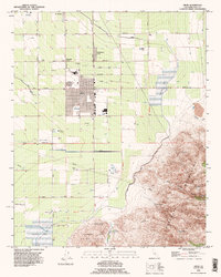
1992 Map of Arvin
USGS Topo · Published 1995About this map
Agricultural development and industrial extraction define this corner of the San Joaquin Valley in the early 1990s. The city of Arvin serves as a central hub, surrounded by a grid of orchards and vineyards supported by an extensive network of pipelines, canals, and levees. Smaller community nodes like Di Giorgio, Edmundson Acres, and Mitchells Corner emphasize the area's history as a center for labor and large-scale farming. To the north, the presence of the Oil Field and numerous oil wells reflects the region's mineral wealth.
Find a feature on this map
47 named features on this map. Tap any name to fly to it.
Don’t see what you’re looking for? This feature index may not catch every label — zoom into the map to look around manually.
Map Details
Editions of this 1992 Arvin Map
This is the sole edition of this map. No revisions or reprints were ever made.
Other maps of this area

1914 · Caliente
USGS Topo · 1:125,000

1929 · Bena
USGS Topo · 1:31,680

1929 · Fairfax School
USGS Topo · 1:31,680

1930 · Weed Patch
USGS Topo · 1:31,680

1930 · Bear Mountain
USGS Topo · 1:31,680

1930 · Arvin
USGS Topo · 1:31,680

1931 · West of Tejon Hills
USGS Topo · 1:31,680

1931 · Edison
USGS Topo · 1:31,680

1931 · Tejon Hills
USGS Topo · 1:31,680

1932 · Bena
USGS Topo · 1:31,680