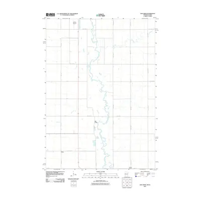
2010 Map of Ash Creek
USGS Topo · Published 2010About this map
Rock River winds southward through this rural landscape, serving as a primary geographic anchor for the region. The map highlights the small settlement of Ash Creek and the surrounding agricultural grid defined by routes like County Hwy-1 and County Hwy-16. For genealogists and local historians, the presence of Eastside Cemetery and Ebenezer Cemetery provides specific locations for tracing family heritage within the township. The northern edge of the map features the Luverne Municipal Airport, marking a modern transportation hub amidst the traditional farm-to-market road network. Numerous creek systems, including Elk Creek and the namesake Ash Creek, cut across the section lines, illustrating the natural drainage patterns that have shaped land use and local property boundaries for generations.
Find a feature on this map
24 named features on this map. Tap any name to fly to it.
Don’t see what you’re looking for? This feature index may not catch every label — zoom into the map to look around manually.
Map Details
Editions of this 2010 Ash Creek Map
This is the sole edition of this map. No revisions or reprints were ever made.
Other maps of this area

1955 · Sioux Falls
USGS Topo · 1:250,000

1958 · Sioux Falls
USGS Topo · 1:250,000

1967 · Magnolia
USGS Topo · 1:24,000

1967 · Hills
USGS Topo · 1:24,000

1967 · Hills NE
USGS Topo · 1:24,000

1967 · Ellsworth
USGS Topo · 1:24,000

1967 · Ash Creek
USGS Topo · 1:24,000
1967 · Luverne
USGS Topo · 1:24,000

1971 · Edna
USGS Topo · 1:24,000

1971 · Lester
USGS Topo · 1:24,000