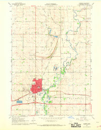
1967 Map of Luverne
USGS Topo · Published 1969About this map
The Rock River valley and the quartzite heights of The Blue Mound define the landscape of Rock County in the late 1960s. The city of Luverne serves as a regional hub, its grid including landmarks like the City Hall, Armory, and the St Catherines Sch. Transportation is central to the area's layout, with the Chicago Rock Island and Pacific and Chicago and North Western railroads intersecting near the County Fairground. Outside the city center, the terrain is marked by a legacy of stone and soil extraction, evidenced by several Quarries and Gravel Pits along the river's path. Cultural and community sites are well-documented, from the Blue Mound Wayside Chapel to the Drive-in Theater south of town, while multiple burial grounds such as Maplewood Cemetery and the Norwegian Cem provide vital records for genealogical research.
Find a feature on this map
50 named features on this map. Tap any name to fly to it.
Don’t see what you’re looking for? This feature index may not catch every label — zoom into the map to look around manually.
Map Details
Editions of this 1967 Luverne Map
2 editions found
Other maps of this area

1955 · Sioux Falls
USGS Topo · 1:250,000

1958 · Sioux Falls
USGS Topo · 1:250,000

1967 · Edgerton South
USGS Topo · 1:24,000

1967 · Magnolia
USGS Topo · 1:24,000

1967 · Hills
USGS Topo · 1:24,000

1967 · Kenneth
USGS Topo · 1:24,000

1967 · Jasper SE
USGS Topo · 1:24,000

1967 · Hills NE
USGS Topo · 1:24,000

1967 · Ellsworth
USGS Topo · 1:24,000

1967 · Ash Creek
USGS Topo · 1:24,000