
1988 Map of Ashburnham
USGS Topo · Published 1988About this map
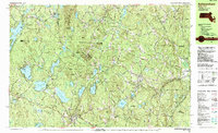
Lake Monomonac and the surrounding woodlands of northern Massachusetts define this landscape at the edge of the New Hampshire border. This 1980s topography reveals a region characterized by numerous glacial ponds and significant state-managed lands, including Ashburnham State Forest and Willard Brook State Forest. The town center of Ashburnham serves as a primary hub, while smaller named clusters like Wellville, North Ashburnham, and Lane Village reflect the distributed nature of residential growth in these wooded hills.
Find a feature on this map
93 named features on this map. Tap any name to fly to it.
Don’t see what you’re looking for? This feature index may not catch every label — zoom into the map to look around manually.
Map Details
Editions of this 1988 Ashburnham Map
2 editions found
Other maps of this area

1887 · Winchendon
USGS Topo · 1:62,500

1887 · Fitchburg
USGS Topo · 1:62,500

1889 · Fitchburg
USGS Topo · 1:62,500

1890 · Winchendon
USGS Topo · 1:62,500

1893 · Fitchburg
USGS Topo · 1:62,500

1893 · Groton
USGS Topo · 1:62,500

1894 · Winchendon
USGS Topo · 1:62,500

1898 · Monadnock
USGS Topo · 1:62,500

1900 · Peterboro
USGS Topo · 1:62,500

1906 · Milford
USGS Topo · 1:62,500