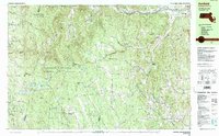
1990 Map of Ashfield
USGS Topo · Published 1990About this map
The Kenneth M Dubuque Memorial State Forest and Mohawk Trail State Forest dominate the high ground of the Berkshire foothills on this 1990 map. This intersection of Berkshire, Franklin, and Hampshire counties reveals a landscape defined by small upland settlements and the headwaters of the Deerfield River and Westfield River systems. Local genealogy and settlement history are well-preserved through numerous small burying grounds, including the Doane Cem near Hawley and the Hilltop Cem overlooking Plainfield.
Find a feature on this map
78 named features on this map. Tap any name to fly to it.
Don’t see what you’re looking for? This feature index may not catch every label — zoom into the map to look around manually.
Map Details
Editions of this 1990 Ashfield Map
2 editions found
Other maps of this area

1885 · Northampton
USGS Topo · 1:62,500

1886 · Greylock
USGS Topo · 1:62,500

1886 · Hawley
USGS Topo · 1:62,500

1886 · Chesterfield
USGS Topo · 1:62,500

1886 · Northampton
USGS Topo · 1:62,500

1886 · Becket
USGS Topo · 1:62,500

1888 · Becket
USGS Topo · 1:62,500

1888 · Chesterfield
USGS Topo · 1:62,500

1890 · Hawley
USGS Topo · 1:62,500

1890 · Greenfield
USGS Topo · 1:62,500