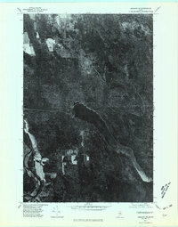
1975 Map of Ashland SE
USGS Topo · Published 1981About this map
Squa Pan Lake dominates this orthophotoquad, which utilizes 1975 aerial photography to document the landscape of north-central Aroostook County. Unlike traditional line-drawn maps, this image provides a direct visual record of timber harvesting patterns and land use at the intersection of water and forest. Along the western edge, the Aroostook River winds through the terrain near the small community of Masardis, where cleared fields contrast sharply with the dense coniferous cover that defines most of the region. The map also reveals the prominent elevation of Brushy Hill to the north, offering researchers a clear view of the wilderness as it appeared during the mid-1970s. This visual record is particularly valuable for identifying historic shorelines and the extent of forest roads that served the local timber industry during this era.
Find a feature on this map
4 named features on this map. Tap any name to fly to it.
Don’t see what you’re looking for? This feature index may not catch every label — zoom into the map to look around manually.
Map Details
Editions of this 1975 Ashland SE Map
This is the sole edition of this map. No revisions or reprints were ever made.
Other maps of this area

1931 · Ashland
USGS Topo · 1:48,000

1934 · Ashland
USGS Topo · 1:62,500

1935 · Howe Brook
USGS Topo · 1:48,000

1935 · Presque Isle
USGS Topo · 1:62,500

1939 · Howe Brook
USGS Topo · 1:62,500

1940 · Oxbow
USGS Topo · 1:62,500

1942 · Oxbow
USGS Topo · 1:62,500

1953 · Ashland
USGS Topo · 1:62,500

1953 · Presque Isle
USGS Topo · 1:62,500

1954 · Howe Brook
USGS Topo · 1:62,500