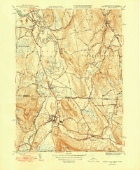
1949 Map of Ashley Falls
USGS Topo · Published 1949About this map
The Housatonic River meanders through the central valley of this mid-century survey, defining a landscape where Massachusetts and Connecticut agriculture and industry intersect. Following the river's path, the New York New Haven and Hartford RR links the primary settlements of Sheffield, Ashley Falls, and Canaan, illustrating the importance of rail transit to the regional economy. The map documents a blend of rural and developed space, featuring the Canaan Landing Field just south of the state line and several small burial grounds like Center Cem and Hewins Cem that speak to the area's genealogical history. Significant terrain features, including Miles Mtn and Canaan Mtn, flank the fertile lowlands of the Blackberry River and Konkapot River, while numerous small local roads such as Shunpike Road and Alum Hill Road connect scattered family farmsteads and rural homesites.
Find a feature on this map
60 named features on this map. Tap any name to fly to it.
Don’t see what you’re looking for? This feature index may not catch every label — zoom into the map to look around manually.
Map Details
Editions of this 1949 Ashley Falls Map
2 editions found
Other maps of this area

1885 · Sheffield
USGS Topo · 1:62,500

1888 · Sheffield
USGS Topo · 1:62,500

1888 · Sandisfield
USGS Topo · 1:62,500

1891 · Sheffield
USGS Topo · 1:62,500

1892 · Winsted
USGS Topo · 1:62,500

1892 · Cornwall
USGS Topo · 1:62,500

1893 · Sheffield
USGS Topo · 1:62,500

1893 · Cornwall
USGS Topo · 1:62,500

1893 · Sandisfield
USGS Topo · 1:62,500

1897 · Sandisfield
USGS Topo · 1:62,500