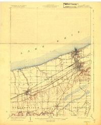
1905 Map of Ashtabula
USGS Topo · Published 1927About this map
The industrial and maritime activity of Ashtabula centers on its deep-water Harbor and the mouth of the Ashtabula River, where a dense network of rail yards supports the movement of cargo between the Great Lakes and the interior. The shoreline of Lake Erie is already developing into a recreational destination, evidenced by settlements like Geneva on the Lake and Buckeye Beach. Inland, the landscape transitions into agricultural townships, where the Grand River carves a deep valley through Harpersfield, passing the small community of Mechanicsville. This era represents a peak for rail transit in Northern Ohio, with the Lake Shore and Michigan Southern and the New York Chicago and St Louis railroads cutting straight east-west paths across the coastal plain. For researchers, the map provides a clear look at early village structures in Austinburg and Saybrook before modern suburban expansion altered the rural character of the county.
Find a feature on this map
33 named features on this map. Tap any name to fly to it.
Don’t see what you’re looking for? This feature index may not catch every label — zoom into the map to look around manually.
Map Details
Editions of this 1905 Ashtabula Map
5 editions found
Other maps of this area

1904 · Chardon
USGS Topo · 1:62,500

1905 · Andover
USGS Topo · 1:48,000

1905 · Ashtabula
USGS Topo · 1:62,500

1905 · Perry
USGS Topo · 1:62,500

1905 · Jefferson
USGS Topo · 1:62,500

1906 · Chardon
USGS Topo · 1:62,500

1906 · Conneaut
USGS Topo · 1:62,500

1907 · Andover
USGS Topo · 1:62,500

1907 · Jefferson
USGS Topo · 1:62,500

1950 · Cleveland
USGS Topo · 1:250,000