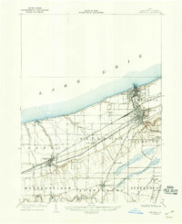
1905 Map of Ashtabula
USGS Topo · Published 1946About this map
The industrial and maritime activity of Lake Erie's shoreline dominates this survey, where the Ashtabula River meets the Harbor. At the turn of the century, Ashtabula and the neighboring settlement of Sweden served as critical nodes for coal and ore transit, supported by a dense concentration of rail infrastructure including the Pennsylvania System and the Michigan Southern and Lake Shore lines. Inland, the landscape transitions from the developed lakefront to agricultural and riverine areas, defined by the winding course of the Grand River and smaller tributaries like Coffee Creek and Mill Creek.
Find a feature on this map
34 named features on this map. Tap any name to fly to it.
Don’t see what you’re looking for? This feature index may not catch every label — zoom into the map to look around manually.
Map Details
Editions of this 1905 Ashtabula Map
5 editions found
Other maps of this area

1904 · Chardon
USGS Topo · 1:62,500

1905 · Andover
USGS Topo · 1:48,000

1905 · Ashtabula
USGS Topo · 1:62,500

1905 · Perry
USGS Topo · 1:62,500

1905 · Jefferson
USGS Topo · 1:62,500

1906 · Chardon
USGS Topo · 1:62,500

1906 · Conneaut
USGS Topo · 1:62,500

1907 · Andover
USGS Topo · 1:62,500

1907 · Jefferson
USGS Topo · 1:62,500

1950 · Cleveland
USGS Topo · 1:250,000