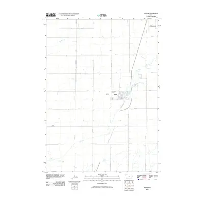
2010 Map of Ashton
USGS Topo · Published 2010About this map
Ashton serves as the central hub of this prairie landscape, where the grid of rural roads meets the diagonal path of Northwest Blvd. The settlement is anchored by local institutions including the Ashton Post Office and two nearby burial grounds, Gilman Cemetery and Saint Marys Cemetery. Outside the town center, the terrain is defined by a dense network of watercourses such as Otter Creek, Rat Creek, and Wagner Creek that break the rigid geometry of the section lines.
Find a feature on this map
27 named features on this map. Tap any name to fly to it.
Don’t see what you’re looking for? This feature index may not catch every label — zoom into the map to look around manually.
Map Details
Editions of this 2010 Ashton Map
This is the sole edition of this map. No revisions or reprints were ever made.
Other maps of this area

1954 · Fairmont
USGS Topo · 1:250,000

1958 · Fairmont
USGS Topo · 1:250,000

1964 · Matlock
USGS Topo · 1:24,000

1964 · Sheldon
USGS Topo · 1:24,000

1964 · Sanborn
USGS Topo · 1:24,000

1972 · Ashton
USGS Topo · 1:24,000
1972 · Little Rock
USGS Topo · 1:24,000

1972 · Sibley West
USGS Topo · 1:24,000
1972 · George East
USGS Topo · 1:24,000

1972 · Cloverdale
USGS Topo · 1:24,000