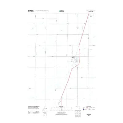
2013 Map of Ashton
USGS Topo · Published 2013About this map
Ashton serves as the central hub of this agricultural landscape in Osceola County, situated at the intersection of a well-defined grid of township roads. The town's layout is clearly delineated by streets such as 1st ST, Johannes ST, and Ashton Ave, with the modern corridor of Highway 60 Blvd and Co Hwy L36 facilitating regional travel. Beyond the town limits, the geography is defined by a network of drainage ways including Otter Cr, Rat Cr, and W Rat Cr, which weave through the surrounding farmland. The presence of the Zylstra Feedlot and the Sibley Municipal Airport at the northern edge indicates the area's mix of traditional agriculture and local aviation infrastructure. This 2013 survey illustrates the persistence of the section-line road system, where routes like McKinley Ave and 230th St maintain the orderly development of the Iowa plains.
Find a feature on this map
32 named features on this map. Tap any name to fly to it.
Don’t see what you’re looking for? This feature index may not catch every label — zoom into the map to look around manually.
Map Details
Editions of this 2013 Ashton Map
This is the sole edition of this map. No revisions or reprints were ever made.
Other maps of this area

1954 · Fairmont
USGS Topo · 1:250,000

1958 · Fairmont
USGS Topo · 1:250,000

1964 · Matlock
USGS Topo · 1:24,000

1964 · Sheldon
USGS Topo · 1:24,000

1964 · Sanborn
USGS Topo · 1:24,000

1972 · Ashton
USGS Topo · 1:24,000
1972 · Little Rock
USGS Topo · 1:24,000

1972 · Sibley West
USGS Topo · 1:24,000
1972 · George East
USGS Topo · 1:24,000

1972 · Cloverdale
USGS Topo · 1:24,000