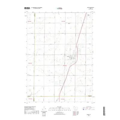
2018 Map of Ashton
USGS Topo · Published 2018About this map
The town of Ashton serves as the focal point of this Northwest Iowa landscape, situated on the edge of the Coteau des Prairies upland. The 2018 survey reveals a well-defined agricultural grid typical of Osceola County, punctuated by several historical burial sites including Saint Marys Cem and Gilman Cem near the town center, while Quaker Cem lies further west. The drainage of the region is characterized by small tributaries like Otter Cr, Rat Cr, and Kappes Cr, which thread through the sections of farmland. Bordered by several county lines, the map details the intersection of Lyon, Sioux, O'Brien, and Osceola counties. Near the northern margin, the Sibley Municipal Airport marks the transition toward the county seat, while the local infrastructure is defined by a dense network of numbered and named section roads like McKinley Ave and Co HWY a34.
Find a feature on this map
53 named features on this map. Tap any name to fly to it.
Don’t see what you’re looking for? This feature index may not catch every label — zoom into the map to look around manually.
Map Details
Editions of this 2018 Ashton Map
This is the sole edition of this map. No revisions or reprints were ever made.
Other maps of this area

1954 · Fairmont
USGS Topo · 1:250,000

1958 · Fairmont
USGS Topo · 1:250,000

1964 · Matlock
USGS Topo · 1:24,000

1964 · Sheldon
USGS Topo · 1:24,000

1964 · Sanborn
USGS Topo · 1:24,000

1972 · Ashton
USGS Topo · 1:24,000
1972 · Little Rock
USGS Topo · 1:24,000

1972 · Sibley West
USGS Topo · 1:24,000
1972 · George East
USGS Topo · 1:24,000

1972 · Cloverdale
USGS Topo · 1:24,000