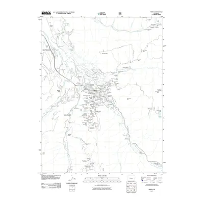
2011 Map of Aspen
USGS Topo · Published 2011About this map
Aspen's legacy as a silver mining powerhouse is laid bare on this topographic survey, which reveals an incredibly dense network of shafts and tunnels surrounding the town. The slopes of Aspen Mountain and Red Mountain are marked by dozens of claims, including the Mollie Gibson Shaft, Aspen Mine, and the Free Silver Mine. To the northeast, the settlement of Lenado sits near the Champion Shaft Mine, connected by the winding Lenado Gulch.
Find a feature on this map
190 named features on this map. Tap any name to fly to it.
Don’t see what you’re looking for? This feature index may not catch every label — zoom into the map to look around manually.
Map Details
Editions of this 2011 Aspen Map
This is the sole edition of this map. No revisions or reprints were ever made.
Other maps of this area

1893 · Aspen
USGS Topo · 1:62,500

1895 · Aspen
USGS Topo · 1:62,500

1909 · Mount Jackson
USGS Topo · 1:125,000

1911 · Mount Jackson
USGS Topo · 1:125,000

1957 · Leadville
USGS Topo · 1:250,000

1959 · Leadville
USGS Topo · 1:250,000

1960 · Leadville
USGS Topo · 1:250,000

1960 · Highland Peak
USGS Topo · 1:24,000

1960 · Maroon Bells
USGS Topo · 1:24,000
1960 · Hayden Peak
USGS Topo · 1:24,000