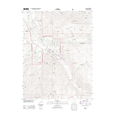
2013 Map of Aspen
USGS Topo · Published 2013About this map
The Roaring Fork River carves through this high-altitude landscape, defining the urban center of Aspen and its surrounding peaks. This 2013 survey illustrates the dense network of recreational and industrial history, from the Buttermilk Ski Area and the slopes of Aspen Mountain to the outlying settlement of Lenado in the northeast. The map provides a detailed view of the town's early footprint, including Red Butte Cem, Aspen Grove Cem, and Ute Cem, which serve as critical points for genealogical research. Higher elevations are marked by landmarks like the Mountain Bell Reflector on Smuggler Mountain and the expansive reaches of the White River National Forest. The presence of several historic water features, such as the Salvation Ditch and Red Mountain Ditch, highlights the early engineering required to support this mountain community's growth and survival.
Find a feature on this map
125 named features on this map. Tap any name to fly to it.
Don’t see what you’re looking for? This feature index may not catch every label — zoom into the map to look around manually.
Map Details
Editions of this 2013 Aspen Map
This is the sole edition of this map. No revisions or reprints were ever made.
Other maps of this area

1893 · Aspen
USGS Topo · 1:62,500

1895 · Aspen
USGS Topo · 1:62,500

1909 · Mount Jackson
USGS Topo · 1:125,000

1911 · Mount Jackson
USGS Topo · 1:125,000

1957 · Leadville
USGS Topo · 1:250,000

1959 · Leadville
USGS Topo · 1:250,000

1960 · Leadville
USGS Topo · 1:250,000

1960 · Highland Peak
USGS Topo · 1:24,000

1960 · Maroon Bells
USGS Topo · 1:24,000
1960 · Hayden Peak
USGS Topo · 1:24,000