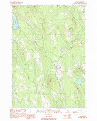
1989 Map of Athens
USGS Topo · Published 1989About this map
Wesserunsett Stream anchors the central valley of this Somerset County landscape, flowing southward through the village of Athens. The settlement pattern follows a network of ridges and rural crossroads, including West Athens, Corsons Corner, and Cass Corner. These small hamlets are connected by state routes 150, 151, and 43, which navigate the topographic rise of Chapman Ridge and the prominent West Ridge.
Find a feature on this map
38 named features on this map. Tap any name to fly to it.
Don’t see what you’re looking for? This feature index may not catch every label — zoom into the map to look around manually.
Map Details
Editions of this 1989 Athens Map
This is the sole edition of this map. No revisions or reprints were ever made.
Other maps of this area

1903 · Bingham
USGS Topo · 1:62,500

1904 · Anson
USGS Topo · 1:62,500

1905 · Bingham
USGS Topo · 1:62,500

1913 · Skowhegan
USGS Topo · 1:62,500

1948 · Bangor
USGS Topo · 1:250,000

1948 · Kingsbury
USGS Topo · 1:62,500

1950 · Kingsbury
USGS Topo · 1:62,500

1954 · Millinocket
USGS Topo · 1:250,000

1955 · Anson
USGS Topo · 1:62,500

1955 · Skowhegan
USGS Topo · 1:62,500