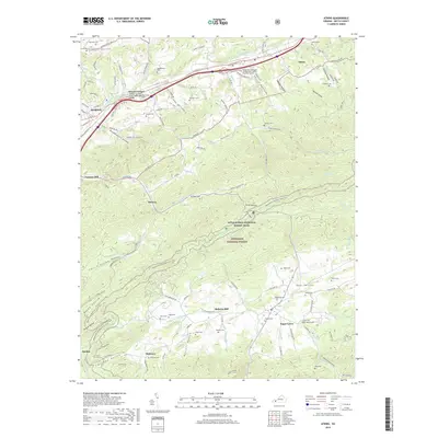
2019 Map of Atkins
USGS Topo · Published 2019About this map
Marion and Atkins anchor this portion of the Holston River valley, where the Middle Fork Holston River and the Norfolk Southern railroad dictate the corridor of travel. The landscape transitions from the urban edges of Marion to the dense woodland of the Jefferson National Forest. Deep in the southern valleys, older settlements like Sugar Grove, Slabtown, and Quebec remain connected by rural routes such as Lead Mine Rd, hinting at the area's industrial past. Numerous family burial sites, including the Keesling Cem and Ridgelawn Cem, are scattered across the terrain from Mitchell Valley to Rye Valley. The Appalachian National Scenic Trail winds through the central ridges, crossing over Brushy Mountain RD and through Long Hollow, providing a clear record of modern recreational infrastructure layered over a historical agricultural and mining landscape.
Find a feature on this map
126 named features on this map. Tap any name to fly to it.
Don’t see what you’re looking for? This feature index may not catch every label — zoom into the map to look around manually.
Map Details
Editions of this 2019 Atkins Map
This is the sole edition of this map. No revisions or reprints were ever made.
Other maps of this area

1889 · Wytheville
USGS Topo · 1:125,000

1891 · Abingdon
USGS Topo · 1:125,000

1892 · Wytheville
USGS Topo · 1:125,000

1894 · Abingdon
USGS Topo · 1:125,000

1909 · Abingdon
USGS Topo · 1:96,000

1911 · Abingdon
USGS Topo · 1:125,000

1931 · Rural Retreat
USGS Topo · 1:48,000
1934 · Chatham Hill
USGS Topo · 1:24,000

1935 · Nebo
USGS Topo · 1:24,000

1935 · Mouth of Wilson
USGS Topo · 1:48,000