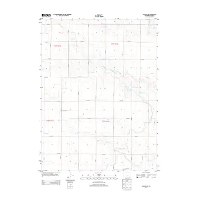
2013 Map of Atwood NE
USGS Topo · Published 2013About this map
Springdale Spring serves as a vital water source in this corner of Logan County, fueling the seasonal flows of Springdale Creek and Springdale Cr. The landscape is defined by an extensive grid of section-line roads, such as Co Road 44 and Co Road 30, which facilitate movement across the agricultural terrain. The engineering of the High Plains is evident in the water management systems, including the N Sterling Canal and the Pawnee Ditch, which redirect water to support local farming operations. While much of the area remains open rangeland or cultivated fields, small residential clusters begin to appear near the southern boundary, marked by local streets like Bluestem St, Deerfield St, and Skyline Ct. Further south, the dry bed of Sand Creek meanders through the plains, illustrating the arid hydrology characteristic of the region.
Find a feature on this map
31 named features on this map. Tap any name to fly to it.
Don’t see what you’re looking for? This feature index may not catch every label — zoom into the map to look around manually.
Map Details
Editions of this 2013 Atwood NE Map
This is the sole edition of this map. No revisions or reprints were ever made.
Other maps of this area

1951 · Willard
USGS Topo · 1:24,000

1951 · Sterling South
USGS Topo · 1:24,000

1951 · Sterling North
USGS Topo · 1:24,000

1951 · Wild Horse Lake
USGS Topo · 1:24,000

1951 · Atwood NE
USGS Topo · 1:24,000

1951 · Atwood
USGS Topo · 1:24,000

1952 · Padroni
USGS Topo · 1:24,000

1954 · Sterling
USGS Topo · 1:250,000

1958 · Sterling
USGS Topo · 1:250,000
1978 · North Sterling Reservoir
USGS Topo · 1:24,000