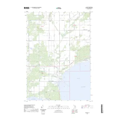
2023 Map of Au Gres
USGS Topo · Published 2023About this map
The Au Gres River defines the landscape of this Lake Huron coastal region, winding through the expansive Au Gres Swamp before emptying into Saginaw Bay at the town of Au Gres. This contemporary survey reflects a territory where drainage and hydrology remain central to the community's layout, evidenced by a dense network of artificial waterways like Cedar Creek Drain and Dime Drain that manage the low-lying terrain. Genealogy and local heritage are anchored by the Linwood Cem near the river and an Indian Burial Ground situated further south. Beyond the main settlement, the smaller locales of Santiago and Delano appear along the inland grid of section lines, surrounded by landmarks of environmental and agricultural management such as the Duck Lake Swamp and the Farm Service Agency office.
Find a feature on this map
95 named features on this map. Tap any name to fly to it.
Don’t see what you’re looking for? This feature index may not catch every label — zoom into the map to look around manually.
Map Details
Editions of this 2023 Au Gres Map
This is the sole edition of this map. No revisions or reprints were ever made.
Other maps of this area

1954 · Flint
USGS Topo · 1:250,000

1954 · Tawas City
USGS Topo · 1:250,000

1958 · Flint
USGS Topo · 1:250,000

1958 · Tawas City
USGS Topo · 1:250,000

1966 · Point Lookout
USGS Topo · 1:24,000

1966 · Au Gres
USGS Topo · 1:24,000

1966 · Alabaster
USGS Topo · 1:24,000

1966 · National City
USGS Topo · 1:24,000
1967 · Standish NE
USGS Topo · 1:24,000

1968 · Whittemore
USGS Topo · 1:24,000