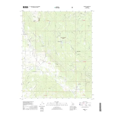
2018 Map of Auberry
USGS Topo · Published 2018About this map
Meadow Lakes and the surrounding Fresno County foothills are presented here as they appeared in 2018, characterized by a complex network of forest roads and small communities nestled within the Sierra National Forest. The map documents the transition from the San Joaquin River at Horseshoe Bend in the northwest to the higher elevations of Burrough Mtn and Black Mtn in the south. The settlement patterns of Auberry, New Auberry, and Tollhouse reflect the historical importance of mountain transit and timber, with the Tollhouse Cem providing a specific point of interest for genealogical research. Local landmarks such as Big Sandy Bluff and the curiously labeled Baptist Camp (aka Acorn?) indicate the mixed-use nature of this landscape, where recreation and seasonal residences sit alongside established rural villages.
Find a feature on this map
82 named features on this map. Tap any name to fly to it.
Don’t see what you’re looking for? This feature index may not catch every label — zoom into the map to look around manually.
Map Details
Editions of this 2018 Auberry Map
This is the sole edition of this map. No revisions or reprints were ever made.
Other maps of this area

1904 · Kaiser
USGS Topo · 1:125,000

1912 · Mariposa
USGS Topo · 1:125,000

1922 · Trimmer
USGS Topo · 1:96,000

1923 · Academy
USGS Topo · 1:31,680

1924 · Dinuba
USGS Topo · 1:125,000

1942 · Watts Valley
USGS Topo · 1:62,500

1942 · Millerton Lake
USGS Topo · 1:62,500

1944 · Watts Valley
USGS Topo · 1:62,500

1945 · Millerton Lake
USGS Topo · 1:62,500
1946 · Clovis
USGS Topo · 1:62,500