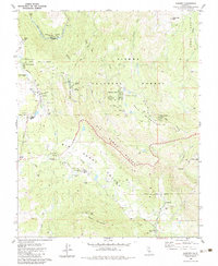
1983 Map of Auberry
USGS Topo · Published 1983About this map
Big Sandy Rancheria and the surrounding Sierra Nevada foothills define this 1983 topographic study of Fresno County. The landscape is a mix of small settlements and national forest lands, centered around the community of Auberry and the newer developments of New Auberry. The map captures a transitional period of infrastructure, showing several communication facilities such as the Radio Facility (KJEO) and Radio Facilities (KAIL) situated atop high ground near Meadow Lakes. Educational hubs like the Sierra Joint Union High Sch and Auberry Union Sch serve the scattered population. The geography is dominated by the San Joaquin River at Horseshoe Bend and the wide floor of Big Sandy Valley, providing a detailed look at the rural road network including Powerhouse Road and Auberry Road before modern expansion.
Find a feature on this map
50 named features on this map. Tap any name to fly to it.
Don’t see what you’re looking for? This feature index may not catch every label — zoom into the map to look around manually.
Map Details
Editions of this 1983 Auberry Map
This is the sole edition of this map. No revisions or reprints were ever made.
Other maps of this area

1904 · Kaiser
USGS Topo · 1:125,000

1912 · Mariposa
USGS Topo · 1:125,000

1922 · Trimmer
USGS Topo · 1:96,000

1923 · Academy
USGS Topo · 1:31,680

1924 · Dinuba
USGS Topo · 1:125,000

1942 · Watts Valley
USGS Topo · 1:62,500

1942 · Millerton Lake
USGS Topo · 1:62,500

1944 · Watts Valley
USGS Topo · 1:62,500

1945 · Millerton Lake
USGS Topo · 1:62,500
1946 · Clovis
USGS Topo · 1:62,500