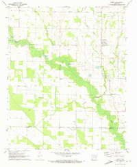
1971 Map of Aubrey
USGS Topo · Published 1973About this map
The lowlands of the Arkansas Delta define this landscape, where the meandering course of Big Creek and its associated wetlands dominate the topography. Local life in the early 1970s was centered around small crossroads communities like Aubrey and the curiously named Turkey Scratch, the latter situated right on the border of Lee Co and Phillips Co. This survey illustrates a rural economy transitioning between traditional agriculture and specialized land use, evidenced by the presence of a Fish Farm near Spring Creek and a Landing Strip in the southern portion of the quadrangle.
Find a feature on this map
26 named features on this map. Tap any name to fly to it.
Don’t see what you’re looking for? This feature index may not catch every label — zoom into the map to look around manually.
Map Details
Editions of this 1971 Aubrey Map
This is the sole edition of this map. No revisions or reprints were ever made.
Other maps of this area

1940 · Marvell
USGS Topo · 1:62,500

1940 · Holly Grove
USGS Topo · 1:62,500

1940 · Brinkley
USGS Topo · 1:62,500

1940 · Marianna
USGS Topo · 1:62,500

1948 · Helena
USGS Topo · 1:250,000

1950 · Helena
USGS Topo · 1:250,000

1955 · Helena
USGS Topo · 1:250,000

1956 · Marvell
USGS Topo · 1:62,500
1957 · Marianna
USGS Topo · 1:62,500

1957 · Holly Grove
USGS Topo · 1:62,500