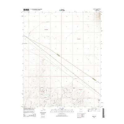
2014 Map of Audley
USGS Topo · Published 2014About this map
Audley sits along the historic corridor of Az-66, illustrating the settlement patterns of the high desert in Northern Arizona. This landscape is defined by its ranching infrastructure, characterized by numerous water catchments including Lemonade Tank, Little Soto Tank, and Norton Tank. The map documents a transition in land use, showing a dense network of modern residential-style street names such as W La Plancha Pky and N Calle Carlotta south of the highway, contrasting with the wide-open ranch lands of the Aubrey Valley. The county boundary between Coconino Co and Yavapai Co cuts diagonally across the eastern portion of the quadrangle, which is further shaped by historical transit routes like Pica Camp Rd and Audley Rd.
Find a feature on this map
54 named features on this map. Tap any name to fly to it.
Don’t see what you’re looking for? This feature index may not catch every label — zoom into the map to look around manually.
Map Details
Editions of this 2014 Audley Map
This is the sole edition of this map. No revisions or reprints were ever made.
Other maps of this area

1886 · Diamond Creek
USGS Topo · 1:250,000

1886 · Chino
USGS Topo · 1:250,000

1891 · Chino
USGS Topo · 1:250,000

1892 · Diamond Creek
USGS Topo · 1:250,000

1948 · Williams
USGS Topo · 1:250,000

1954 · Williams
USGS Topo · 1:250,000

1956 · Williams
USGS Topo · 1:250,000

1960 · Williams
USGS Topo · 1:250,000

1961 · Williams
USGS Topo · 1:250,000
1980 · Audley
USGS Topo · 1:24,000