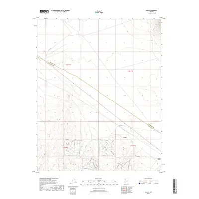
2018 Map of Audley
USGS Topo · Published 2018About this map
Audley sits at the intersection of high-desert infrastructure and ranching history, positioned along the historic route of 66 as it crosses the boundary of Coconino and Yavapai Counties. This 2018 survey reveals a landscape of transition, where the wide expanses of the Aubrey Valley meet a developing network of named roads such as Bridge Canyon Pkwy and Mesa Pkwy. The mapping detail focuses heavily on water management in an arid environment, documenting numerous livestock and catchment basins including Norton Tank, Little Soto Tank, and Audley Tank. The presence of Pica Camp Rd and various local thoroughfares like Tambor Rd and Rotrero Pkwy suggests a pattern of modern parceling and residential expansion within a terrain traditionally defined by its open range and the proximity of the rail-and-highway corridor.
Find a feature on this map
45 named features on this map. Tap any name to fly to it.
Don’t see what you’re looking for? This feature index may not catch every label — zoom into the map to look around manually.
Map Details
Editions of this 2018 Audley Map
This is the sole edition of this map. No revisions or reprints were ever made.
Other maps of this area

1886 · Diamond Creek
USGS Topo · 1:250,000

1886 · Chino
USGS Topo · 1:250,000

1891 · Chino
USGS Topo · 1:250,000

1892 · Diamond Creek
USGS Topo · 1:250,000

1948 · Williams
USGS Topo · 1:250,000

1954 · Williams
USGS Topo · 1:250,000

1956 · Williams
USGS Topo · 1:250,000

1960 · Williams
USGS Topo · 1:250,000

1961 · Williams
USGS Topo · 1:250,000
1980 · Audley
USGS Topo · 1:24,000