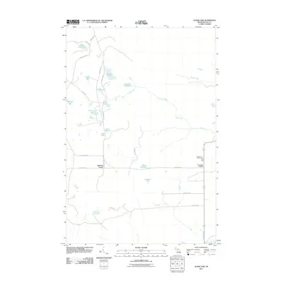
2011 Map of Auger Lake
USGS Topo · Published 2011About this map
Auger Lake and the winding course of Auger Creek define this section of Columbus Township in the early 21st century. The landscape is marked by a dense network of remote water bodies, including Cleveland Cliffs Lake, Halfway Lake, and Spring Hill Lake, illustrating the glacial hydrology of the Upper Peninsula. Human activity is concentrated along the local road system, anchored by rural junctions like Eightmile Corner and Fourmile Corner. The southern edge of the survey is bounded by the Tahquamenon River and the drainage of Brant Creek, while the northeastern corner shows a connection to the Northcountry Campground. The presence of several camp-named features, such as Camp Seven Lake and Camp Five Lake, suggests a history of timber or recreational outposts throughout this wooded interior of Luce County.
Find a feature on this map
33 named features on this map. Tap any name to fly to it.
Don’t see what you’re looking for? This feature index may not catch every label — zoom into the map to look around manually.
Map Details
Editions of this 2011 Auger Lake Map
This is the sole edition of this map. No revisions or reprints were ever made.
Other maps of this area

1954 · Sault Sainte Marie
USGS Topo · 1:250,000

1956 · Sault Sainte Marie
USGS Topo · 1:250,000

1957 · Sault Sainte Marie
USGS Topo · 1:250,000

1958 · Sault Sainte Marie
USGS Topo · 1:250,000

1962 · Auger Lake
USGS Topo · 1:24,000

1968 · Muskallonge Lake SW
USGS Topo · 1:24,000

1968 · Muskallonge Lake SE
USGS Topo · 1:24,000

1968 · Betsy Lake SW
USGS Topo · 1:24,000
1973 · McMillan
USGS Topo · 1:24,000
1973 · Newberry
USGS Topo · 1:24,000