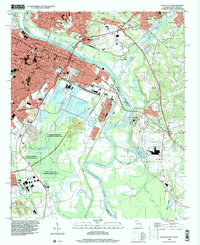
1995 Map of Augusta East
USGS Topo · Published 2000About this map
The Savannah River serves as the central artery and state boundary in this mid-1990s snapshot of the urban corridor between Georgia and South Carolina. On the western bank, the grid of Augusta reveals a dense network of civic and educational institutions, including the University of Georgia Medical College, Paine College, and Union Station. This side of the river is also defined by its historic funerary landscapes, notably Magnolia Cemetery and Cedar Grove Cemetery.
Find a feature on this map
75 named features on this map. Tap any name to fly to it.
Don’t see what you’re looking for? This feature index may not catch every label — zoom into the map to look around manually.
Map Details
Editions of this 1995 Augusta East Map
This is the sole edition of this map. No revisions or reprints were ever made.
Other maps of this area

1892 · Mc Cormick
USGS Topo · 1:125,000

1912 · Mc Cormick
USGS Topo · 1:125,000

1920 · Clarks Hill
USGS Topo · 1:48,000

1921 · Augusta
USGS Topo · 1:62,500

1921 · Clarks Hill
USGS Topo · 1:62,500

1922 · Hephzibah
USGS Topo · 1:62,500

1923 · Warrenville
USGS Topo · 1:48,000

1928 · Warrenville
USGS Topo · 1:62,500

1941 · Clarks Hill
USGS Topo · 1:62,500

1942 · Clarks Hill
USGS Topo · 1:62,500