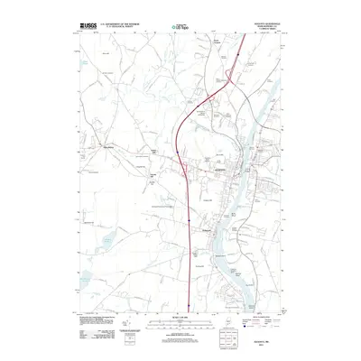
2011 Map of Augusta
USGS Topo · Published 2011About this map
The Kennebec River corridor defines the geography of the state capital and its neighboring towns in this 2011 survey. The landscape is characterized by a dense concentration of civic and commemorative sites, including the Maine Veterans Memorial Cemetery, the University of Maine at Augusta, and the historic grounds of Camp Keyes. Topographical features such as Granite Hill and Howard Hill overlook the river valley, where water management is marked by the Vaughn Brook Dam and Hallowell Recreation Pond Dam. In the western portion of the quadrangle, the village of Manchester sits near the Augusta Golf Course, while the river itself features navigational landmarks like Britts Shoal and the Augusta Seaplane Base. This detailed record captures the modern footprint of Augusta and Hallowell, preserving the locations of numerous family and municipal burial grounds from Coombs Cemetery to Riverside Cemetery.
Find a feature on this map
142 named features on this map. Tap any name to fly to it.
Don’t see what you’re looking for? This feature index may not catch every label — zoom into the map to look around manually.
Map Details
Editions of this 2011 Augusta Map
This is the sole edition of this map. No revisions or reprints were ever made.
Other maps of this area

1892 · Gardiner
USGS Topo · 1:62,500

1892 · Augusta
USGS Topo · 1:62,500

1893 · Vassalboro
USGS Topo · 1:62,500

1893 · Wiscasset
USGS Topo · 1:62,500

1898 · Vassalboro
USGS Topo · 1:62,500

1941 · Vassalboro
USGS Topo · 1:62,500

1941 · Augusta
USGS Topo · 1:62,500

1943 · Augusta
USGS Topo · 1:62,500

1943 · Gardiner
USGS Topo · 1:62,500

1943 · Vassalboro
USGS Topo · 1:62,500