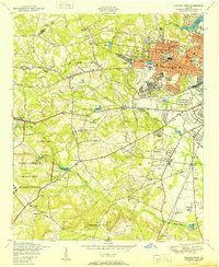
1950 Map of Augusta West
USGS Topo · Published 1950About this map
The Augusta Arsenal and Daniel Field anchor the western expansion of Augusta in the mid-century, where urban street grids transition into the rolling terrain of Richmond County. This area shows a dense concentration of civic and social institutions, from the Richmond Academy to the extensive grounds of Westover Memorial Cemetery. The landscape is defined by the heavy presence of the Camp Gordon Military Reservation to the southwest, bordered by Butler Creek.
Find a feature on this map
73 named features on this map. Tap any name to fly to it.
Don’t see what you’re looking for? This feature index may not catch every label — zoom into the map to look around manually.
Map Details
Editions of this 1950 Augusta West Map
This is the sole edition of this map. No revisions or reprints were ever made.
Other maps of this area

1892 · Mc Cormick
USGS Topo · 1:125,000

1912 · Mc Cormick
USGS Topo · 1:125,000

1920 · Clarks Hill
USGS Topo · 1:48,000

1921 · Augusta
USGS Topo · 1:62,500

1921 · Clarks Hill
USGS Topo · 1:62,500

1922 · Hephzibah
USGS Topo · 1:62,500

1923 · Warrenville
USGS Topo · 1:48,000

1928 · Warrenville
USGS Topo · 1:62,500

1941 · Clarks Hill
USGS Topo · 1:62,500

1942 · Clarks Hill
USGS Topo · 1:62,500