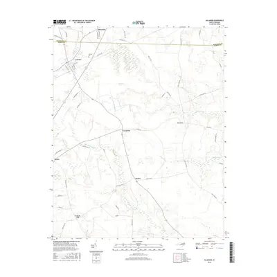
2016 Map of Aulander
USGS Topo · Published 2016About this map
Aulander serves as the primary hub in this portion of the Inner Banks, situated just south of the Hertford Co and Bertie Co line. The landscape is defined by its extensive wetlands and pocosins—unique evergreen shrub bogs—including Hearts Delight Pocosin, Beaverdam Pocosin, and Connarita Pocosin. These natural features, along with the slow-moving waters of Beaverdam Swamp and Connarita Swamp, historically dictated the placement of small agricultural settlements and rural infrastructure. Genealogy researchers will find several small communities and crossroads such as Millennium, Hexlena, Connarita, and Rhodes, alongside the Eastview Cem near Aulander. The presence of Francis Mill in the southwest corner of the quadrangle highlights the enduring connection between the local hydrology and early milling industries in this coastal plain region.
Find a feature on this map
48 named features on this map. Tap any name to fly to it.
Don’t see what you’re looking for? This feature index may not catch every label — zoom into the map to look around manually.
Map Details
Editions of this 2016 Aulander Map
This is the sole edition of this map. No revisions or reprints were ever made.
Other maps of this area

1908 · Winton
USGS Topo · 1:62,500

1953 · Norfolk
USGS Topo · 1:250,000

1972 · Republican
USGS Topo · 1:24,000

1972 · Woodville
USGS Topo · 1:24,000

1972 · Aulander
USGS Topo · 1:24,000

1973 · Kelford
USGS Topo · 1:24,000

1977 · Union
USGS Topo · 1:24,000

1977 · Woodland
USGS Topo · 1:24,000
1981 · Windsor North
USGS Topo · 1:24,000

1982 · Powellsville
USGS Topo · 1:24,000