
2011 Map of Aurora
USGS Topo · Published 2011About this map
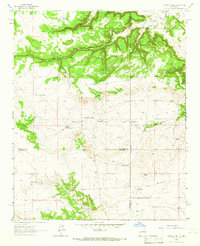
Gonzales Ranch and its neighboring settlements define this pocket of San Miguel County, where ranching life centers on the drainage of the Arroyo de los Diegos. The map reveals a landscape deeply carved by numerous canyons, including Cañon de Mucha Agua and Cañon Gordo, illustrating how the terrain dictates the placement of early road networks and isolated ranching outposts. Family-named landmarks such as the Pablo Sena Ranch, Benevides Ranch, and Snyder Ranch are scattered across the mesas and valleys, providing essential locations for genealogists tracking local ancestry in the Aurora vicinity. Unusual landmarks like the East Windmill and the pool at Laguna Seca highlight the critical role of water management in this arid region, while the prominent peak of El Cerrito de la Chimaja serves as a distinct navigational anchor in the southern portion of the quadrangle.
Find a feature on this map
30 named features on this map. Tap any name to fly to it.
Don’t see what you’re looking for? This feature index may not catch every label — zoom into the map to look around manually.
Map Details
Editions of this 2011 Aurora Map
This is the sole edition of this map. No revisions or reprints were ever made.
Other maps of this area

1890 · Bernal
USGS Topo · 1:125,000

1891 · Bernal
USGS Topo · 1:125,000

1894 · Bernal
USGS Topo · 1:125,000

1894 · Lamy
USGS Topo · 1:125,000

1954 · Santa Fe
USGS Topo · 1:250,000

1958 · Santa Fe
USGS Topo · 1:250,000

1960 · Villanueva
USGS Topo · 1:62,500

1963 · Jacinto Mesa
USGS Topo · 1:24,000

1963 · Aurora
USGS Topo · 1:24,000
1963 · Potrillo Hill
USGS Topo · 1:24,000