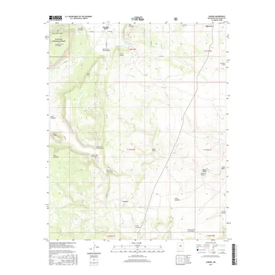
2017 Map of Aurora
USGS Topo · Published 2017About this map
Villanueva and Gonzales Ranch anchor the northern reaches of this high-altitude landscape in San Miguel County, where the Pecos River valley terrain transitions into a complex system of mesas and canyons. The settlement of Aurora sits further south, surrounded by a network of seasonal watercourses such as Arroyo Guajalote and Arroyo Calaveras. This 2017 survey reveals a geography defined by its deep arroyos and prominent landforms, including Mesa Sacatosa and the heights of Pinos Altos. A portion of the Santa Fe National Forest extends into the northwest corner, protecting areas like La Mesa Corral de la Agua. The map documents a rural New Mexico landscape where traditional place names like Puerta de la Primera Agua and Cañon Juan Francisco persist alongside modern county road designations, reflecting a long history of land use and navigation through the arroyos.
Find a feature on this map
43 named features on this map. Tap any name to fly to it.
Don’t see what you’re looking for? This feature index may not catch every label — zoom into the map to look around manually.
Map Details
Editions of this 2017 Aurora Map
This is the sole edition of this map. No revisions or reprints were ever made.
Other maps of this area

1890 · Bernal
USGS Topo · 1:125,000

1891 · Bernal
USGS Topo · 1:125,000

1894 · Bernal
USGS Topo · 1:125,000

1894 · Lamy
USGS Topo · 1:125,000

1954 · Santa Fe
USGS Topo · 1:250,000

1958 · Santa Fe
USGS Topo · 1:250,000

1960 · Villanueva
USGS Topo · 1:62,500

1963 · Jacinto Mesa
USGS Topo · 1:24,000

1963 · Aurora
USGS Topo · 1:24,000
1963 · Potrillo Hill
USGS Topo · 1:24,000