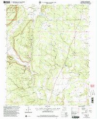
2002 Map of Aurora
USGS Topo · Published 2003About this map
Gonzales Ranch anchors the northern reaches of this New Mexico landscape, situated at the edge of the Santa Fe National Forest. This 2002 revision captures a rural settlement pattern defined by isolated ranches and essential community landmarks, including the Santa Teresita Ch and the Gonzales Ranch Sch. The terrain is deeply incised by complex drainage systems such as Cañon de los Diegos and Cañon Gordo, which channel seasonal water from high mesas toward the southern plains. The prevalence of named water sources and landmarks, like Laguna Seca, Bustos Well, and the West Tank, reflects the vital importance of water management in this arid environment. Moving south toward Aurora, the map documents several historic family holdings, including the Pablo Sena Ranch and Benevides Ranch, connected by a network of four-wheel-drive trails that navigate the mesas and arroyos.
Find a feature on this map
51 named features on this map. Tap any name to fly to it.
Don’t see what you’re looking for? This feature index may not catch every label — zoom into the map to look around manually.
Map Details
Editions of this 2002 Aurora Map
This is the sole edition of this map. No revisions or reprints were ever made.
Other maps of this area

1890 · Bernal
USGS Topo · 1:125,000

1891 · Bernal
USGS Topo · 1:125,000

1894 · Bernal
USGS Topo · 1:125,000

1894 · Lamy
USGS Topo · 1:125,000

1954 · Santa Fe
USGS Topo · 1:250,000

1958 · Santa Fe
USGS Topo · 1:250,000

1960 · Villanueva
USGS Topo · 1:62,500

1963 · Jacinto Mesa
USGS Topo · 1:24,000

1963 · Aurora
USGS Topo · 1:24,000
1963 · Potrillo Hill
USGS Topo · 1:24,000