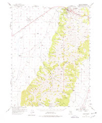
1956 Map of Austin
USGS Topo · Published 1978About this map
The mining community of Austin serves as the focal point of this 1956 survey, where the town is tucked into Pony Canyon beneath the looming heights of Central Hill and Mt Prometheus. The map captures the area's rich history as a silver mining hub and a key stop on the Lincoln Highway. Notable landmarks such as Stokes Castle stand on the slopes overlooking the town, while the surrounding Toiyabe National Forest is defined by a dense network of canyons and peaks, including Toiyabe Peak and Bunker Hill.
Find a feature on this map
55 named features on this map. Tap any name to fly to it.
Don’t see what you’re looking for? This feature index may not catch every label — zoom into the map to look around manually.
Map Details
Editions of this 1956 Austin Map
3 editions found
Other maps of this area

1926 · Roberts Mountains
USGS Topo · 1:250,000

1929 · Roberts Mountains
USGS Topo · 1:250,000

1955 · Millett
USGS Topo · 1:250,000

1956 · Mount Callaghan
USGS Topo · 1:62,500

1956 · North Shoshone Peak
USGS Topo · 1:62,500

1956 · Millett Ranch
USGS Topo · 1:62,500

1956 · Austin
USGS Topo · 1:62,500

1959 · Millett
USGS Topo · 1:250,000

1960 · Spencer Hot Springs
USGS Topo · 1:62,500

1960 · Wildcat Peak
USGS Topo · 1:62,500