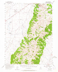
1956 Map of Austin
USGS Topo · Published 1964About this map
Austin sits at the northern edge of the Toiyabe Range, a high-altitude mining town overlooking the wide desert valleys of central Nevada in the mid-1950s. The landscape is defined by the steep elevation changes between the Reese River basin and the sharp peaks of Toiyabe Peak and Bunker Hill. Historic infrastructure is evident in the Dismantled Railroad and the iconic Stokes Castle standing watch over Marshall Canyon. The valley floor is dotted with established homesteads like the Carter Ranch and Gandolfo Ranch, while the mountains are carved by numerous drainages including Big Creek and Birch Creek. Within the Toiyabe National Forest, the map records early service sites like the Kingston Ranger Station and various mining operations such as the Apex Mine. The transit corridor follows the historic Lincoln Highway, passing the Austin Airport as it traverses the high desert terrain.
Find a feature on this map
53 named features on this map. Tap any name to fly to it.
Don’t see what you’re looking for? This feature index may not catch every label — zoom into the map to look around manually.
Map Details
Editions of this 1956 Austin Map
3 editions found
Other maps of this area

1926 · Roberts Mountains
USGS Topo · 1:250,000

1929 · Roberts Mountains
USGS Topo · 1:250,000

1955 · Millett
USGS Topo · 1:250,000

1956 · Mount Callaghan
USGS Topo · 1:62,500

1956 · North Shoshone Peak
USGS Topo · 1:62,500

1956 · Millett Ranch
USGS Topo · 1:62,500

1956 · Austin
USGS Topo · 1:62,500

1959 · Millett
USGS Topo · 1:250,000

1960 · Spencer Hot Springs
USGS Topo · 1:62,500

1960 · Wildcat Peak
USGS Topo · 1:62,500