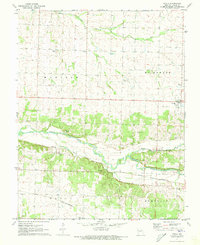
1971 Map of Avilla
USGS Topo · Published 1973About this map
Avilla serves as the primary hub in this early 1970s survey of eastern Jasper County, situated at the junction of regional transit lines. The Spring River meanders across the lower half of the quadrangle, drawing a divide between the townships of Madison and Sarcoxie. This landscape is deeply etched with the markers of a settled rural community, characterized by numerous family and community burial grounds such as Summerset Cem, Arthur Cem, and Fasken Cem.
Find a feature on this map
24 named features on this map. Tap any name to fly to it.
Don’t see what you’re looking for? This feature index may not catch every label — zoom into the map to look around manually.
Map Details
Editions of this 1971 Avilla Map
This is the sole edition of this map. No revisions or reprints were ever made.
Other maps of this area

1886 · Carthage
USGS Topo · 1:125,000

1894 · Carthage
USGS Topo · 1:125,000

1921 · Sarcoxie
USGS Topo · 1:62,500

1947 · Joplin
USGS Topo · 1:250,000

1949 · Joplin
USGS Topo · 1:250,000

1954 · Joplin
USGS Topo · 1:250,000

1958 · Joplin
USGS Topo · 1:250,000

1959 · Joplin
USGS Topo · 1:250,000
1962 · Jasper
USGS Topo · 1:24,000
1962 · Dudenville
USGS Topo · 1:24,000