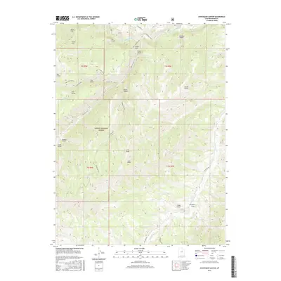
2017 Map of Avintaquin Canyon
USGS Topo · Published 2017About this map
Ashley National Forest defines the high-desert and canyon landscape of this Duchesne County region, where the Strawberry River cuts through the northern reaches. The terrain is a network of named drainages and high points, including Timber Point and the prominent Long Ridge, illustrating the complex topography that historically dictated movement through the Uinta Basin. A series of established paths like the Bull Hollow Trail and Cow Hollow Trail follow natural contours, connecting various hollows such as Calf Hollow and Lion Hollow. In the southern portion, Avintaquin Cr winds through Avintaquin Canyon near the flat expanse of Wilbur Bench. This map documents a modern view of land use where forestry boundaries and primitive access roads intersect with remote water sources like Sagers Spring and Minnie Cr.
Find a feature on this map
35 named features on this map. Tap any name to fly to it.
Don’t see what you’re looking for? This feature index may not catch every label — zoom into the map to look around manually.
Map Details
Editions of this 2017 Avintaquin Canyon Map
This is the sole edition of this map. No revisions or reprints were ever made.
Other maps of this area

1885 · Uinta
USGS Topo · 1:250,000

1886 · Price River
USGS Topo · 1:250,000

1896 · Price River
USGS Topo · 1:250,000

1954 · Salt Lake City
USGS Topo · 1:250,000

1956 · Price
USGS Topo · 1:250,000

1958 · Salt Lake City
USGS Topo · 1:250,000

1960 · Salt Lake City
USGS Topo · 1:250,000

1960 · Price
USGS Topo · 1:250,000

1962 · Price
USGS Topo · 1:250,000

1962 · Deep Creek Canyon
USGS Topo · 1:24,000