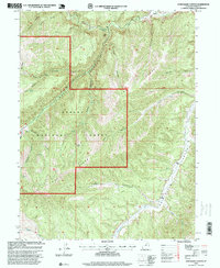
1996 Map of Avintaquin Canyon
USGS Topo · Published 1999About this map
Ashley National Forest dominates the high-elevation landscape of this Utah quadrangle, where steep drainages and prominent ridges define the rugged topography south of the Strawberry River. The area is characterized by a network of seasonal draws and deep canyons, including the extensive Timber Canyon and the winding Avintaquin Canyon. Human presence is marked by isolated cattle ranching operations at the edge of the forest boundaries, notably Remund Ranch in the north and Pearross Ranch along the lower reaches of Avintaquin Creek.
Find a feature on this map
30 named features on this map. Tap any name to fly to it.
Don’t see what you’re looking for? This feature index may not catch every label — zoom into the map to look around manually.
Map Details
Editions of this 1996 Avintaquin Canyon Map
This is the sole edition of this map. No revisions or reprints were ever made.
Other maps of this area

1885 · Uinta
USGS Topo · 1:250,000

1886 · Price River
USGS Topo · 1:250,000

1896 · Price River
USGS Topo · 1:250,000

1954 · Salt Lake City
USGS Topo · 1:250,000

1956 · Price
USGS Topo · 1:250,000

1958 · Salt Lake City
USGS Topo · 1:250,000

1960 · Salt Lake City
USGS Topo · 1:250,000

1960 · Price
USGS Topo · 1:250,000

1962 · Price
USGS Topo · 1:250,000

1962 · Deep Creek Canyon
USGS Topo · 1:24,000