Loading...
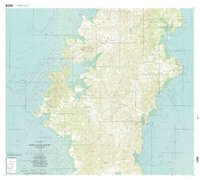
Loading map...2000 Map of Babeldaob South
USGS Topo · Published 2004About this map
Babeldaob island’s southern interior and coastline are meticulously documented in this survey based on imagery from the turn of the millennium. The landscape is defined by the central Kedam ridge, which serves as the island's spine, separating the western reaches of Ngeremeduu Bay from the eastern settlements of Melekeok and Ngchesar. On the western coast, the Ngeremeduu Conservation Area preserves the complex estuarine environment where numerous streams meet the sea near Ngeremeduu.
Find a feature on this map
47 named features on this map. Tap any name to fly to it.
Don’t see what you’re looking for? This feature index may not catch every label — zoom into the map to look around manually.
Map Details
Date Portrayed2000
Date Published2004
PublisherU.S. Geological Survey
Map TypeTopographic
Scale1:25,000
Physical Dimensions40.03 x 36.08 inches
Editions of this 2000 Babeldaob South Map
This is the sole edition of this map. No revisions or reprints were ever made.
Other maps of this area
Featured Places
Source Details
SourceU.S. Geological Survey
CopyrightPublic Domain