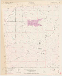
1973 Map of Bachelor Mtn
USGS Topo · Published 1976About this map
Skinner Reservoir dominates the central landscape of this 1973 revision, marking a significant period of water infrastructure development in Riverside County. The San Diego Aqueduct cuts across the western terrain, underscoring the region's reliance on managed water systems to support its growing agricultural and residential needs. While the reservoir represents modern engineering, older markers of the rural community remain, such as the Alamos Sch and the Hyatt Sch (Aban'd), reflecting the shifting population centers of the mid-20th century.
Find a feature on this map
41 named features on this map. Tap any name to fly to it.
Don’t see what you’re looking for? This feature index may not catch every label — zoom into the map to look around manually.
Map Details
Editions of this 1973 Bachelor Mtn Map
This is the sole edition of this map. No revisions or reprints were ever made.
Other maps of this area

1901 · Southern California Sheet No. 1
USGS Topo · 1:250,000

1901 · San Jacinto
USGS Topo · 1:125,000

1901 · Elsinore
USGS Topo · 1:125,000

1901 · San Luis Rey
USGS Topo · 1:125,000

1903 · Ramona
USGS Topo · 1:125,000

1904 · Southern California Sheet No. 2
USGS Topo · 1:250,000

1904 · Southern California Sheet No. 1
USGS Topo · 1:250,000

1939 · Palomar Mountain
USGS Topo · 1:62,500

1942 · Temecula
USGS Topo · 1:62,500

1942 · Hemet
USGS Topo · 1:62,500