
1942 Map of Hemet
USGS Topo · Published 1952About this map
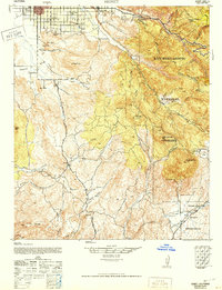
The San Jacinto Valley transitions from the orderly agricultural grids of Hemet and Valle Vista into the steep, complex terrain of the San Bernardino National Forest. Compiled from 1939-1941 aerial photography, the map reveals a landscape defined by seasonal watercourses like Bautista Creek and the San Jacinto River carving through granite uplands. Cultural landmarks such as the Ramona Bowl sit just south of the main settlement, while further into the backcountry, remote outposts like the San Ignacio Sch and the Williamson Mine highlight the era's scattered mountain habitation. The southern portion of the map covers the Coahuila Indian Reservation and Coahuila Valley, providing an important record of tribal lands and naming conventions such as Juan Diego Flat and Tripp Flats before modern development altered these rural corridors.
Find a feature on this map
49 named features on this map. Tap any name to fly to it.
Don’t see what you’re looking for? This feature index may not catch every label — zoom into the map to look around manually.
Map Details
Editions of this 1942 Hemet Map
2 editions found
Other maps of this area

1901 · Southern California Sheet No. 1
USGS Topo · 1:250,000

1901 · San Jacinto
USGS Topo · 1:125,000

1901 · Elsinore
USGS Topo · 1:125,000

1901 · San Luis Rey
USGS Topo · 1:125,000

1903 · Ramona
USGS Topo · 1:125,000

1904 · Southern California Sheet No. 2
USGS Topo · 1:250,000

1904 · Southern California Sheet No. 1
USGS Topo · 1:250,000

1939 · Warner Springs
USGS Topo · 1:62,500

1939 · Palomar Mountain
USGS Topo · 1:62,500

1940 · Palm Springs
USGS Topo · 1:62,500