1942 Map of Hemet
USGS Topo · Published 1952About this map
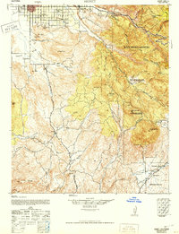
Hemet and the San Jacinto Valley are shown here as they appeared during the early 1940s, a period when the agricultural character of the valley floor contrasted sharply with the surrounding mountains. The famous Ramona Bowl sits at the foot of the hills, marking the location of the long-running outdoor pageant. To the east, the landscape transitions into the San Bernardino National Forest, where the terrain is punctuated by significant peaks like Little Coahuila Mtn and Coahuila Mtn.
Find a feature on this map
50 named features on this map. Tap any name to fly to it.
Don’t see what you’re looking for? This feature index may not catch every label — zoom into the map to look around manually.
Map Details
Editions of this 1942 Hemet Map
2 editions found

Other maps of this area

1901 · Southern California Sheet No. 1
USGS Topo · 1:250,000

1901 · San Jacinto
USGS Topo · 1:125,000

1901 · Elsinore
USGS Topo · 1:125,000

1901 · San Luis Rey
USGS Topo · 1:125,000

1903 · Ramona
USGS Topo · 1:125,000

1904 · Southern California Sheet No. 2
USGS Topo · 1:250,000

1904 · Southern California Sheet No. 1
USGS Topo · 1:250,000

1939 · Warner Springs
USGS Topo · 1:62,500

1939 · Palomar Mountain
USGS Topo · 1:62,500

1940 · Palm Springs
USGS Topo · 1:62,500