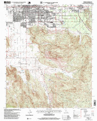
1996 Map of Hemet
USGS Topo · Published 1999About this map
Hemet serves as the primary urban center in this 1990s revision, showcasing the grid-based residential expansion and commercial density typical of Riverside County at the end of the twentieth century. To the east, the unincorporated community of Valle Vista follows the natural contours of the valley, while the isolated Searl Ranch marks the more rural, agricultural character of the southern landscape. The transition from the managed municipal streets of the city to the steep, undeveloped slopes of the surrounding hills highlights the era's balance between suburban growth and the preservation of National Forest System lands managed by the Forest Service. This specific survey reflects a period where legacy landholdings and modern development existed side-by-side before further regional intensification.
Find a feature on this map
3 named features on this map. Tap any name to fly to it.
Don’t see what you’re looking for? This feature index may not catch every label — zoom into the map to look around manually.
Map Details
Editions of this 1996 Hemet Map
This is the sole edition of this map. No revisions or reprints were ever made.
Other maps of this area

1901 · Southern California Sheet No. 1
USGS Topo · 1:250,000

1901 · San Jacinto
USGS Topo · 1:125,000

1901 · Elsinore
USGS Topo · 1:125,000

1904 · Southern California Sheet No. 1
USGS Topo · 1:250,000

1942 · Banning
USGS Topo · 1:62,500

1942 · Hemet
USGS Topo · 1:62,500

1942 · Murrieta
USGS Topo · 1:62,500

1942 · Perris
USGS Topo · 1:62,500

1943 · Perris
USGS Topo · 1:62,500
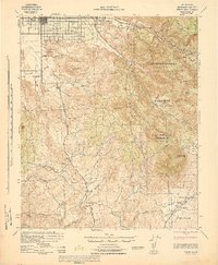
1943 · Hemet
USGS Topo · 1:62,500